


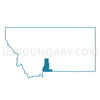
7-B Springdale, Park County, Montana
About
Outline

Summary
| Unique Area Identifier | 612187 |
| Name | 7-B Springdale |
| County | Park County |
| State | Montana |
| Area (square miles) | 80.50 |
| Land Area (square miles) | 80.03 |
| Water Area (square miles) | 0.47 |
| % of Land Area | 99.41 |
| % of Water Area | 0.59 |
| Latitude of the Internal Point | 45.76374040 |
| Longtitude of the Internal Point | -110.35926760 |
Maps


Graphs
Select a template below for downloading or customizing gragh for 7-B Springdale, Park County, Montana


Neighbors
Neighoring Voting District (by Name) Neighboring Voting District on the Map
- 6-B Outer Livingston, Park County, MT
- 7-A Upper Missi, Park County, MT
- 7-D Clyde Park, Park County, MT
Top 10 Neighboring County Subdivision (by Population) Neighboring County Subdivision on the Map
- Livingston CCD, Park County, MT (12,325)
- South of the Yellowstone CCD, Sweet Grass County, MT (2,840)
- Shields Valley CCD, Park County, MT (1,785)
- North of the Yellowstone CCD, Sweet Grass County, MT (811)
Top 10 Neighboring Place (by Population) Neighboring Place on the Map
Top 10 Neighboring Elementary School District (by Population) Neighboring Elementary School District on the Map
- Livingston Elementary School District, MT (10,406)
- Shields Valley Elementary School District, MT (1,628)
- McLeod Elementary School District, MT (223)
- Springdale Elementary School District, MT (131)
Top 10 Neighboring Secondary School District (by Population) Neighboring Secondary School District on the Map
- Park High School District, MT (12,795)
- Sweet Grass County High School District, MT (3,559)
- Shields Valley High School District, MT (1,628)
Top 10 Neighboring State Legislative District Lower Chamber (by Population) Neighboring State Legislative District Lower Chamber on the Map
Top 10 Neighboring State Legislative District Upper Chamber (by Population) Neighboring State Legislative District Upper Chamber on the Map
Top 10 Neighboring 111th Congressional District (by Population) Neighboring 111th Congressional District on the Map
Top 10 Neighboring Census Tract (by Population) Neighboring Census Tract on the Map
- Census Tract 2, Park County, MT (4,067)
- Census Tract 9670, Sweet Grass County, MT (3,651)
- Census Tract 1, Park County, MT (1,785)